Last week I reported on the Volvo Ocean Team Vestas Wind running aground on shoals 270 miles off Mauritius. The team have admitted human error in the accident, discussing exactly what happened in a press conference you can listen to here.
Essentially the navigator didn’t spot the shoal on his electronic charting system so plotted the route right across them. Oops… Where the navigator Wouter Verbraak is one of the best in the business, he admits he hadn’t thought to zoom in on the entire route before he went to bed that night, and awoke to all hell breaking loose on deck.
In his statement, Verbraak refers to a blog post that discusses the finer points of oceanic passage planning and navigation. In that blog the expert navigator says of Verbraak that “Wouter Verbraak is one of the best, and firmly falls into the category of a superb yachtsman and navigator. He is one who understands the strengths and limitations of digital tools more than most will ever do…”
However the same blog suggests that many sailors with a nifty piece of software make the mistake of thinking that the software makes them a navigator. It states, “software does not make someone a navigator. First you must be a navigator, and then know and understand the strengths and limitations of the tools you have.”
Such over confidence has wrecked many a yacht even before the time of software that can give you overconfidence and result in you holing the second most valuable asset you possess a mile from port…
When most people think of yachting they think of learning how to trim the sails correctly and helm a straight course. Equally, if not more important is doing your navigation correctly. Everyone who has done any sailing will have grounded their boat at some point. It is almost always miscalculation that leads to the incident.

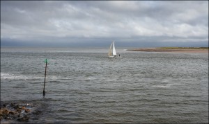
Mouth of the River Exe – submerged sand spit under the smooth water in the background and sewage outlet in the foreground… With thanks to Ted and Jen
The chief difference between an AA Road Map and a sea chart is that the AA Road Map tells you where the sea is, where the chart will tell you what is under it. Wrecks that pose a hazard to navigation are shown, as well as the coral heads that Vestas hit. In some areas such as the Exe Estuary in southern England, the channel is silting up and sandbanks are in constant motion. A new chart will show you where to avoid when entering the port.
The Exe is a classic case for the complete beginner learning to navigate. Popular with sailors (the Queen’s daughter Princess Anne even had a mooring there), a lot of yachting types will want to moor up there. It is a short day sail from Dartmouth and Torbay – both teeming with yachts in the summer. However the sandbanks will catch you out if you can’t read a chart.
For day sailors and offshore yachtsmen alike, a key part of the most developed sailing syllabi will cover navigation and passage planning alike.
In many areas of the world, tides can make the difference between sailing sweetly over some rocks and their taking your keel off. Again, tidal calculations often involve difficult mathematical calculations that will show you the depth of water under the keel at a given time of day and the strength of current passing over it.
Taught in all countries where appropriate, these calculations contribute to effective passage planning that done well, will get you out to sea and home without having to make an embarrassing call on Channel 16 saying you’re stuck…
Common to day and multi night sailing is passage planning. Whether on a day trip to a favoured pub with a dock or blasting up the Indian Ocean in search of glory, you will always have to make a passage plan to get where you’re going.
Passage planning covers the route you are taking, the depths of water on the route, current strength and direction, as well as meteorological conditions expected on the route.
In Verbraak’s case, he’d been up all night the night before navigating the boat through Storm Force winds, and was expecting an easy night when the mistake was made.
Where part of ocean racing is being permanently exhausted for weeks on end and having to be on the button all the time despite round the clock exertion – and Verbraak was no newbie to this – he admits she should have zoomed into the entire route on his chart before crashing in his rack that night.
Where even a newly qualified Yachtmaster Offshore bearer doesn’t know 1/10th of Verbraak’s understanding of oceanic navigation, he will have been taught to check, check, and check again, his proposed route as part of his course.
Where Verbraak will lose sleep over his errors for a long time to come, this shows that even the best can make mistakes.
Lack of training on the part of skippers has cost many millions of dollars more every year than a top navigator’s professional error ever will. Where his error cost the team its place in a race, not every private sailor can say “oh well, better buy a new boat” when his pride and joy loses its keel on a submerged wreck he didn’t recognise on the chart on his way into a new harbour.
A good navigation course will save both your blushes and bank balance…